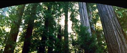
The Eldorado National Forest is one of California's favorites. In a setting of tall pine, fir, and cedars are a myriad of recreational opportunities, like camping, fishing, boating, and hiking.
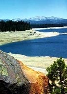
With over 600 miles of streams, water is the most important product, and hydroelectric projects have created many lakes for recreation. The Forest is also host to one wild area in El Dorado County, Desolation Wilderness (almost 43,000 acres). 
Established in 1910, the Forest is situated in the Sierra Nevada Mountains, covering 786,994 acres from the foothills into the rugged alpine country near Lake Tahoe. Elevations range from 1,620 to 10,380 feet. An average of 45 inches of rain falls annually, and 10 to 15 feet of snow are common at higher elevations.
Several years of drought took its toll on the forest, as more than one billion board feet of insect-infested trees died, about 11 percent of the timber inventory. The Forest Service endeavors to harvest dead trees for timber.
 Nugget Nugget
So is it El Dorado or Eldorado? Both spellings are used in El Dorado County. The county and the town names are two words; the national forest is one word. El Dorado as two words is widely used and appears to be correct, "El" being a separate word meaning "The" in Spanish. El Dorado means "The Gilded One". |
Area Code 530 unless noted
|
|
622-5061
642-5122 TTY
|
Visitor Information
|
|
644-6048 |
|
|
644-6048 |
|
|
644-6048 |
|
|
644-6048 |
|
|
644-6048 |
Pacific Ranger Station
7887 Highway 50
Pollock Pines, CA 95726
|
|
644-2349 |
Mt. Danaher Lookout, Camino
CA Dept. Forestry & Fire Protection
|
|
644-2345 |
|
|
543-2600
541-4036 TTY
|
County Burn Day Recording |
|
621-5897
|
Fire Prevention |
|
644-9635 |
County Weed Abatement |
|
644-9635 |
|
|
(707) 562-8737 |
|
|
|
|
|
622-1225
|
Ordering USFS Maps |
|
|
| USFS Campgrounds & Cabins |
|
|