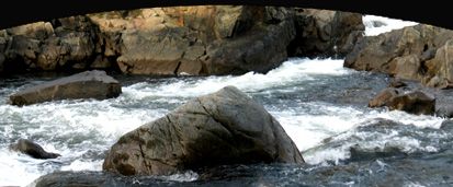

Each year, more than 100,000 people ride the most popular whitewater channel in California, the South Fork of the American River. The rapids are abundant but less turbulent than the North and Middle forks, which offer bigger challenges to more experienced rafters. With names like Bogus Thunder, Triple Threat, Meatgrinder, Troublemaker , Old Scary Rapid, and Murderer's Gorge, it's wise to respect the river at all times, come prepared, and have a blast! See Rafting 
For those who prefer their feet planted firmly on dry ground, there is much history to explore on the shores. The prominent attraction is Marshall Gold Discovery State Historic Park in Coloma, along the South Fork. The Park is located at the site where, in 1848, gold was discovered by James Marshall during the building of Sutter's Mill. You can check out the historic buildings that dot the grounds, visit the Museum (Visitor Center), and picnic at one of the barbeque sites by the river.
Scenic beauty abounds everywhere on the American River. Contributing to the views are more than a thousand plant species, just between Chili Bar and Folsom alone.
Riparian (riverside) plants require a year-round supply of water, and are found in the moist soils along the riverbanks: cottonwood, big leaf maple, Oregon ash, yellow pine, blackberries, willow, wild grapes, white alder, blue oak, black oak valley, live oaks, foothill ("digger") pine, buckeye, and chaparral plants, such as chamise, manzanita, and ceanothus.
To the east, the American River Canyon can be enjoyed when traveling US Hwy. 50 between Pollock Pines and South Lake Tahoe, and includes such historic spots as Riverton, Whitehall, Kyburz, Silver Fork, Fred's Place, Strawberry, Twin Bridges, and Little Norway. See Photo Gallery. This was a popular route used by early travelers (Horace Greeley, Hank Monk) and mail carriers (Snowshoe Thompson, Pony Express riders) who crossed the Sierras by wagon, stage coach, pony, and skis. Read more at the Gold Rush Chronicles.
• Current American River Conditions
• American River Conservancy
• American River at Chili Bar (river stage)
• California Dept. of Boating & Waterways
• AquaSmart Boating Safety
• More about the South Fork American River
• More about rivers in El Dorado County